Day 3: Chase Tomorrow
 Sunday, May 9, 2010 at 9:53 PM
 Tomorrow looks great for storms! We're just hanging out in the hotel. Nothing much to do until the new models come out tomorrow morning then we'll refine our target position. All the dynamics/thermodynamics seem to lining up very well conducive to strong supercells and strong tornadoes. The Storm Prediction Center is saying:
...THERE IS A MDT RISK OF SVR TSTMS ACROSS PORTIONS OF KS/OK TO
SOUTHWEST MO...
...THERE IS A SLGT RISK OF SVR TSTMS ACROSS THE CENTRAL/SOUTHERN
PLAINS TO MIDDLE MS RIVER VALLEY...
...SUPERCELLS WITH STRONG TORNADOES AND VERY LARGE HAIL ARE EXPECTED
MONDAY LATE AFTERNOON AND EVENING ACROSS PARTS OF OK/KS INTO
SOUTHWEST MO...
SOUTHWEST MO...
...THERE IS A SLGT RISK OF SVR TSTMS ACROSS THE CENTRAL/SOUTHERN
PLAINS TO MIDDLE MS RIVER VALLEY...
...SUPERCELLS WITH STRONG TORNADOES AND VERY LARGE HAIL ARE EXPECTED
MONDAY LATE AFTERNOON AND EVENING ACROSS PARTS OF OK/KS INTO
SOUTHWEST MO...
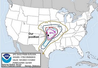
Here is a map that the SPC puts out. I put on there our position so you can see where we are relative to where the storms should be tomorrow:
The "MDT" means a moderate (which is good for chasers) risk of severe storms in the red area. The hatched in pink portions means there's a 45% chance of severe weather 25 miles from any point in the area.


Reader Comments