Day 4: High Risk Chase Day
 Monday, May 10, 2010 at 9:53 AM
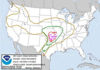
 According to the newest Storm Prediction Center convective outlook, there is a high risk of severe weather today and a 30% chance of significant tornadoes. Here are the maps:
Risk of severe weather:
Risk of tornadoes:
It should be a very interesting day. Right now it's cloudy and rainy. For severe storms to fire up, we need the rain to stop and the clouds to clear up so we get some day time heating. This will help the development of the severe weather. Going to eat and do a briefing this morning on the day's plans such as target areas. We also need to hook up all the equipment in the van. I apologize for the fact that we won't have a direct online internet live feed... However, since today is going to be so active, tune into The Weather Network in the afternoon/evening hours as they will be streaming live video from our chase (if all goes well!). And yes, family, we will be as safe as possible. The people we're chasing with have been doing this for many years and are more than experienced in this area. Needless to say, this is not the first high risk day they've seen.
Day 3: Chase Tomorrow
 Sunday, May 9, 2010 at 9:53 PM
 Tomorrow looks great for storms! We're just hanging out in the hotel. Nothing much to do until the new models come out tomorrow morning then we'll refine our target position. All the dynamics/thermodynamics seem to lining up very well conducive to strong supercells and strong tornadoes. The Storm Prediction Center is saying:
SOUTHWEST MO...
...THERE IS A SLGT RISK OF SVR TSTMS ACROSS THE CENTRAL/SOUTHERN
PLAINS TO MIDDLE MS RIVER VALLEY...
...SUPERCELLS WITH STRONG TORNADOES AND VERY LARGE HAIL ARE EXPECTED
MONDAY LATE AFTERNOON AND EVENING ACROSS PARTS OF OK/KS INTO
SOUTHWEST MO...
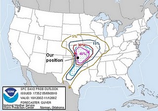
Here is a map that the SPC puts out. I put on there our position so you can see where we are relative to where the storms should be tomorrow:
The "MDT" means a moderate (which is good for chasers) risk of severe storms in the red area. The hatched in pink portions means there's a 45% chance of severe weather 25 miles from any point in the area.
Day 3: Getting Into Position
 Sunday, May 9, 2010 at 6:54 PM
 I'm sitting in a Super 8 motel in Blackwell, Oklahoma with my fellow chasers. We're about to go out and grab some dinner. Meanwhile, there's a nice little thunderstorm firing off just south of us. Nothing crazy but nice to watch. Nothing like what tomorrow will be... But more on that later. We're in perfect position for tomorrow. Right smack dab in the middle of the risk area for tomorrow. I'll update tonight once we talk over the plans for tomorrow. We were going to visit the Twister museum today but unfortunately it was closed today :( Hopefully we can go later this week.
Day 3: Finishing Up the Drive
 Sunday, May 9, 2010 at 8:58 AM
 It's 8:00am in Springfield, Missouri (we're now in the central time zone, an hour behind Toronto). Just got up and going to get ready for the day. We're all meeting downstairs to discuss the plan for the day in about an hour then hit the road again. I'll update later tonight with the day's adventures. As of last night, our target for today was Oklahoma City, maybe meet up with Cloud 9 tours and George Kourounis. However, we'll have to look at the new model runs later this morning to make a better decision. I must say, these beds were amazing and I never wanted to get up! Good morning!
Day 2: The Long Drive Down
 Saturday, May 8, 2010 at 11:00 PM
 Well, currently I'm sitting in a Days Inn in Springfield, Missouri. Unfortunately we didn't have internet until now so this is my first real post about the trip.
Friday: We arrived at Mark's house and go the "chase vehicle". It's a brand spankin' new Chrysler. It's luxury I must tell you. It has Sirius satellite radio, built in DVD player with 2 screens to watch movies, touch screen audio system with mp3 upload capability, stow-n-go seating and a reversing camera. When we picked it up, it only had 87 km on it. The once concern: it has a sunroof. Normally this is not of concern to people... However when there is a possibility for large hail, this is definitely a worry. We've come up with a few plans on building something to put over the sunroof and tie down on the roof racks (possibly a combination of Styrofoam and plywood). After packing in all our gear and setting up the radio antennas, we left Mark's house at around 8:00pm in heavy rain and incredible lightning. The whole drive along the lake shore gave us a spectacular view of the lightning. We took this as a good omen :). The plan was to drive as far as we possibly could that night and definitely make it into the USA. We drove from Toronto to "not-a-clue-where-we-were", Ohio. We drove until we found a random motel on the side of the highway (reminiscent of the movie Joy Ride) at around 3:00am. All we knew was that we were somewhere about 2 hours north of Dayton, Ohio. The motel was sketchy and smelled funky but it did for the night.
Saturday: We were up, packed and ready to get on the road by 9am (little sleep... not fun). We found a Tim Horton's!!!!! Needless to say we had breakfast there. The goal was to get as far south as possible and meet up with Mark's chase buddies Scott McPartland and Dave Lewison. So we drove, drove and drove some more. We met up with Scott and Dave at around 6:00pm and decided that we would head for Springfield, Missouri for the night and make our way towards Oklahoma City, Oklahoma on Sunday. Now the van has roughly 1600 km on it. Here is a map of where we've traveled so far. The red line is our track, start point Toronto, Ontario; end point Springfield, Missouri.
So here I am sitting in the Days Inn. It's luxury compared to the previous night. Right now, models are showing that Monday and Tuesday (possibly Wednesday) are going to be very very good chase days. After talking with Mark, Dave and Scott, they're all very excited about Monday and Tuesday. Right now, according to latest models, it looks like we're headed for south east Kansas or north east Oklahoma. Of course as we get closer to Monday, we'll refine our target area. Tomorrow we have the rest of the drive to do (roughly 6 hours) and then we need to set up the van with our equipment. In the mean time, here's the latest map for Monday:
We're headed for the "MDT" area (moderate chase of severe storms) and "45%" area which means there is a 45% chance of severe whether within 25 miles of any point in the pink blob. In the discussion, the Storm Prediction Center mentions:
KS AND EXTREME SW MO...
...THERE IS A SLGT RISK OF SVR TSTMS FROM THE CNTRL/SRN PLAINS TO
THE MID-MS VLY...
***SUPERCELLS WITH LONG-TRACK STRONG TORNADOES AND VERY LARGE HAIL
EXPECTED MONDAY LATE AFTN/EVENING ACROSS PARTS OF CNTRL/N OK...SE KS
AND SW MO***
Looks like it'll be interesting! If we do get the streaming up and running, you can visit Spotter Network and click on "Current Activity" and this will take you to a map of the USA with GPS locations of different chasers. On the right hand side you'll see the names of the chasers streaming videos. Look for Mark Robinson as one of the streamers. It may or may not be live.
New photos are currently being added to my photo album. Look under the heading of this blog for a link to my photo site.
**Note: streaming video is not yet available. We'll be attempting to set it up tomorrow. However, I've been informed by Mark that The Weather Network will be running promos for this chase event and episodes we're doing starting Monday. I'm not sure of times they'll be airing. As soon as streaming video is available I'll update this.
PS - HAPPY MOTHER'S DAY MOM! I LOVE YOU AND MISS YOU!


